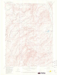
1955 Map of Old Roach
USGS Topo · Published 1970About this map
Old Roach sits at the high-altitude boundary of the Medicine Bow National Forest and Roosevelt National Forest, a site marked as abandoned by the mid-1950s. This survey, conducted for the development of the Missouri River Basin, reveals a landscape of high-country ranching and water management. The Laramie River flows through the northeast corner, flanked by several irrigation channels including Warren Ditch and Boswell Ditch. The presence of Grace Creek Ranch and the Johnson Reservoir suggests a rugged livestock economy dependent on the complex drainage network of Fish Creek, Pole Creek, and Grace Creek. Significant landmarks like Pollock Knob and Mansfield Hill rise above the branching forks of the mountain creeks, providing a clear record of the area's transition from active settlement to forest-managed wilderness.
Find a feature on this map
25 named features on this map. Tap any name to fly to it.
Don’t see what you’re looking for? This feature index may not catch every label — zoom into the map to look around manually.
Map Details
Editions of this 1955 Old Roach Map
5 editions found

Other maps of this area

1895 · Laramie
USGS Topo · 1:125,000

1902 · Laramie
USGS Topo · 1:125,000

1905 · Laramie
USGS Topo · 1:125,000

1906 · Medicine Bow
USGS Topo · 1:125,000

1906 · Laramie
USGS Topo · 1:125,000

1908 · Laramie
USGS Topo · 1:125,000

1908 · Medicine Bow
USGS Topo · 1:125,000

1916 · Home
USGS Topo · 1:125,000

1920 · Home
USGS Topo · 1:125,000

1950 · Kings Canyon
USGS Topo · 1:24,000