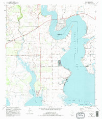
1995 Map of Olivia
USGS Topo · Published 1995About this map
Carancahua Bay and Keller Bay dominate this coastal landscape on the boundary of Jackson and Calhoun counties. The small settlement of Olivia serves as a focal point for local history researchers, featuring the Olivia Cem, the Olivia Community Center, and a nearby Radio Facility. This region in the mid-1990s was defined by a mix of maritime activity and energy extraction, as evidenced by the numerous docks lining the shorelines and the established Oil Field inland. Residential developments like Cape Carancahua and Port Alto overlook the water, protected in parts by Levee systems. The map also captures the path of Keller Creek as it feeds into the bay near Weedhaven, illustrating the drainage patterns and low-lying terrain typical of this stretch of the Texas Gulf Coast.
Find a feature on this map
24 named features on this map. Tap any name to fly to it.
Don’t see what you’re looking for? This feature index may not catch every label — zoom into the map to look around manually.
Map Details
Editions of this 1995 Olivia Map
This is the sole edition of this map. No revisions or reprints were ever made.
Other maps of this area

1951 · Keller Bay
USGS Topo · 1:24,000

1952 · Port Lavaca East
USGS Topo · 1:24,000

1952 · Point Comfort
USGS Topo · 1:24,000

1952 · Olivia
USGS Topo · 1:24,000

1952 · Turtle Bay
USGS Topo · 1:24,000

1952 · Francitas
USGS Topo · 1:24,000

1952 · La Ward
USGS Topo · 1:24,000

1952 · Lolita
USGS Topo · 1:24,000

1953 · Beeville
USGS Topo · 1:250,000

1956 · Beeville
USGS Topo · 1:250,000