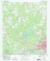
1971 Map of Opelika West
USGS Topo · Published 1983About this map
Opelika and the eastern edge of Auburn anchor this Lee County landscape during a period of significant urban transition. The industrial character of the era is evident at Pepperell, where the Pepperell Sch and local waterworks sit near the Central of Georgia railroad. While the city centers expand, represented by updated urban boundaries and landmarks like the Courthouse and Mc Lure High Sch, the surrounding countryside retains its traditional rural markers. Numerous family and community burial grounds, including Rosemere Cem, Evergreen Cem, and Oak Bowery Cem, are preserved alongside historic crossroads like Stonewall and the uniquely named landmark The Bottle. Waterways such as Sougahatchee Creek and Sandy Creek wind through the terrain, supporting local infrastructure like the Fish Hatchery and Sougahatchee Lake.
Find a feature on this map
61 named features on this map. Tap any name to fly to it.
Don’t see what you’re looking for? This feature index may not catch every label — zoom into the map to look around manually.
Map Details
Editions of this 1971 Opelika West Map
3 editions found
Other maps of this area

1906 · Dadeville
USGS Topo · 1:125,000

1907 · Opelika
USGS Topo · 1:125,000

1909 · Opelika
USGS Topo · 1:125,000

1955 · Phenix City
USGS Topo · 1:250,000

1957 · Phenix City
USGS Topo · 1:250,000

1958 · Phenix City
USGS Topo · 1:250,000

1970 · Opelika East
USGS Topo · 1:24,000

1971 · Waverly
USGS Topo · 1:24,000

1971 · Parkers Crossroads
USGS Topo · 1:24,000
1971 · Cusseta
USGS Topo · 1:24,000