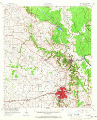
1957 Map of Opelousas
USGS Topo · Published 1967About this map
Opelousas serves as the focal point of this St. Landry Parish survey, shown here at a moment of mid-century growth. The town's urban density is detailed with landmarks like the Academy of Immaculate Conception, Holy Ghost Sch, and the General Hospital, while the St Landry Parish Airport and a Drive-in Theater mark the edges of town. The surrounding prairie is defined by a dense network of bayous and man-made waterways, most notably the Bayou Boeuf-Cocodrie Diversion Channel and its associated Spoil Bank.
Find a feature on this map
67 named features on this map. Tap any name to fly to it.
Don’t see what you’re looking for? This feature index may not catch every label — zoom into the map to look around manually.
Map Details
Editions of this 1957 Opelousas Map
2 editions found

Other maps of this area

1935 · Turkey Creek
USGS Topo · 1:62,500

1939 · Opelousas
USGS Topo · 1:62,500

1940 · Arnaudville
USGS Topo · 1:62,500

1947 · Ville Platte
USGS Topo · 1:31,680

1947 · Chataignier
USGS Topo · 1:31,680

1947 · Pitreville
USGS Topo · 1:31,680

1948 · Bunkie
USGS Topo · 1:62,500

1949 · Turkey Creek
USGS Topo · 1:62,500

1952 · Lake Charles
USGS Topo · 1:250,000

1954 · Lake Charles
USGS Topo · 1:250,000