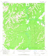
1954 Map of Ophir A-2
USGS Topo · Published 1966About this map
Ophir serves as the primary outpost in this remote Alaskan interior landscape, centered on the Innoko River valley. The map reveals a landscape defined by gold mining history, with a concentration of activity along the eastern drainages. Notable industrial features include a Placer Mine near Spruce Creek and a Landing Strip adjacent to the settlement, essential for bush pilots and supplies.
Find a feature on this map
26 named features on this map. Tap any name to fly to it.
Don’t see what you’re looking for? This feature index may not catch every label — zoom into the map to look around manually.
Map Details
Editions of this 1954 Ophir A-2 Map
3 editions found
Other maps of this area

1951 · Ophir
USGS Topo · 1:250,000

1951 · Iditarod
USGS Topo · 1:250,000

1954 · Ophir A-2
USGS Topo · 1:63,360

1954 · Ophir A-1
USGS Topo · 1:63,360

1954 · Iditarod D-2
USGS Topo · 1:63,360

1954 · Ophir A-3
USGS Topo · 1:63,360

1954 · Ophir B-1
USGS Topo · 1:63,360

1954 · Ophir B-2
USGS Topo · 1:63,360

1954 · Iditarod D-3
USGS Topo · 1:63,360

1954 · Ophir B-3
USGS Topo · 1:63,360