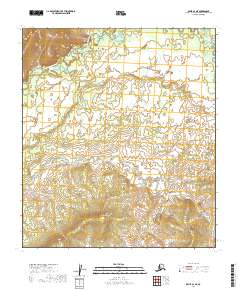
2019 Map of Ophir D-1 NE
USGS Topo · Published 2019About this map
The North Fork Innoko River winds through the northern reaches of this interior Alaskan landscape, defining a broad river valley characterized by complex hydrology and seasonal wetlands. In the southern portion of the sheet, the terrain rises significantly toward the peak of Lone Jim Mtn, which serves as a prominent landmark for the surrounding wilderness. These two features illustrate the stark contrast between the low-lying alluvial plains and the uplands that separate major drainage basins. Drainage from these heights flows into Fourmile Cr, which cuts across the central townships. The absence of roads or established settlements on this 2019 survey emphasizes the continuity of the natural landscape in the Yukon-Koyukuk region, where travel is traditionally dictated by the flow of water and the contours of the mountains.
Find a feature on this map
12 named features on this map. Tap any name to fly to it.
Don’t see what you’re looking for? This feature index may not catch every label — zoom into the map to look around manually.
Map Details
Editions of this 2019 Ophir D-1 NE Map
This is the sole edition of this map. No revisions or reprints were ever made.
Other maps of this area

1945 · Nulato
USGS Topo · 1:250,000

1950 · Medfra
USGS Topo · 1:250,000

1951 · Ophir
USGS Topo · 1:250,000

1951 · Nulato
USGS Topo · 1:250,000

1951 · Ruby
USGS Topo · 1:250,000

1952 · Ruby A-6
USGS Topo · 1:63,360
1952 · Nulato A-1
USGS Topo · 1:63,360

1952 · Nulato
USGS Topo · 1:250,000

1952 · Ruby
USGS Topo · 1:250,000

1954 · Medfra D-6
USGS Topo · 1:63,360