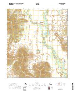
2017 Map of Ophir D-5 NE
USGS Topo · Published 2017About this map
Innoko National Wildlife Refuge dominates the landscape of this interior Alaskan quadrangle, encompassing a vast network of wetlands and meandering waterways. The Little Mud River and its tributary, the W Fork Little Mud River, snake through the terrain, creating complex oxbows and marshy bottomlands. This 2017 survey illustrates a wilderness nearly devoid of human infrastructure, where the natural drainage patterns of the Yukon-Koyukuk region remain the primary geographic features. The map provides precise detail for researchers studying the hydrology and protected habitats within the refuge boundaries, as the rivers shift through the low-lying interior basin.
Find a feature on this map
9 named features on this map. Tap any name to fly to it.
Don’t see what you’re looking for? This feature index may not catch every label — zoom into the map to look around manually.
Map Details
Editions of this 2017 Ophir D-5 NE Map
This is the sole edition of this map. No revisions or reprints were ever made.
Other maps of this area

1945 · Nulato
USGS Topo · 1:250,000

1951 · Ophir
USGS Topo · 1:250,000

1951 · Nulato
USGS Topo · 1:250,000

1952 · Nulato A-5
USGS Topo · 1:63,360

1952 · Nulato A-4
USGS Topo · 1:63,360

1952 · Nulato
USGS Topo · 1:250,000
1953 · Nulato A-4
USGS Topo · 1:63,360
1954 · Ophir D-4
USGS Topo · 1:63,360
1954 · Ophir D-5
USGS Topo · 1:63,360

1954 · Ophir
USGS Topo · 1:250,000