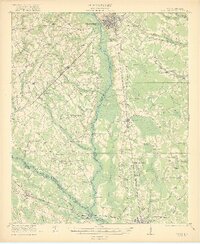
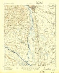
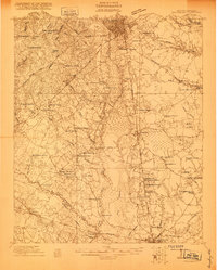
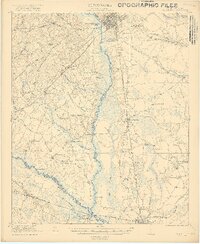
1921 Map of Orangeburg
USGS Topo · Published 1919About this map
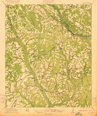
Orangeburg serves as the primary hub of this landscape, situated where the Atlantic Coast Line and Southern Railway converge near the North Fork Edisto River. The river system defines the geography, with the South Fork Edisto River winding through the southwestern reaches and joining the main branch near Branchville. Extensive wetlands like Snake Swamp and Cooper Swamp suggest a low-lying, water-dense terrain that dictated the placement of early infrastructure. Rural social life is remarkably well-documented through a dense network of local institutions, including Bryants Academy, Poplar Spring School, and numerous country congregations such as St George Church and Mt Pisgah Church. This detailed survey also identifies the U S Fish Hatchery and County Farm, reflecting the agrarian and civic priorities of the region after the First World War.
Find a feature on this map
69 named features on this map. Tap any name to fly to it.
Don’t see what you’re looking for? This feature index may not catch every label — zoom into the map to look around manually.
Map Details
Editions of this 1921 Orangeburg Map
3 editions found
Other maps of this area

1919 · Olar
USGS Topo · 1:62,500

1919 · Bamberg
USGS Topo · 1:48,000

1919 · Lodge
USGS Topo · 1:62,500

1920 · Bowman
USGS Topo · 1:48,000

1920 · Lodge
USGS Topo · 1:48,000

1920 · Bamberg
USGS Topo · 1:62,500
1920 · Orangeburg
USGS Topo · 1:48,000

1920 · St. George
USGS Topo · 1:48,000
1921 · Orangeburg
USGS Topo · 1:62,500
1921 · Lodge
USGS Topo · 1:62,500