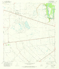
1971 Map of Orchard
USGS Topo · Published 1973About this map
The Orchard Dome Oil and Gas Field dominates this section of Fort Bend County, where petroleum extraction and agricultural infrastructure coexist along the western banks of the Brazos River. The settlement of Orchard serves as a local hub, featuring Artesian Park and the Orchard Community Bldg near the junction of the Atchison Topeka and Santa Fe and an Old Railroad Grade. This 1970s landscape is defined by its industrial activity, with dozens of Gas Wells, Oil Wells, and Gravel Pits peppered throughout the coastal prairie.
Find a feature on this map
35 named features on this map. Tap any name to fly to it.
Don’t see what you’re looking for? This feature index may not catch every label — zoom into the map to look around manually.
Map Details
Editions of this 1971 Orchard Map
3 editions found
Other maps of this area

1950 · Houston
USGS Topo · 1:250,000

1953 · Needville
USGS Topo · 1:24,000

1953 · Kendleton
USGS Topo · 1:24,000

1953 · Hungerford
USGS Topo · 1:24,000

1953 · Seguin
USGS Topo · 1:250,000

1955 · Richmond
USGS Topo · 1:62,500

1956 · Wallis
USGS Topo · 1:62,500

1956 · Houston
USGS Topo · 1:250,000

1958 · Seguin
USGS Topo · 1:250,000

1960 · Wallis
USGS Topo · 1:24,000