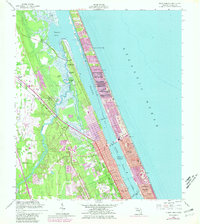
1956 Map of Ormond Beach
USGS Topo · Published 1981About this map
Tomoka State Park dominates the peninsula where the Tomoka River empties into the Tomoka Basin, preserving a landscape of coastal hammocks and wetlands. Evidence of early Spanish and colonial history is visible in landmarks such as the Anacape Mission (Ruins) and the Addison Blockhouse (Ruins) located near National Gardens. The coastal strip shows the mid-century expansion of residential developments like Ormond-by-the-Sea and Ellinor Village, tightly packed between the Atlantic Ocean and the Halifax River. Transport routes are well-defined, including the historic Old Dixie Highway and the Florida East Coast railway. Further south, the map captures the northern edges of Daytona Beach and Holly Hill, alongside established local landmarks like the Ormond Beach Municipal Airport and Hillside Cem.
Find a feature on this map
29 named features on this map. Tap any name to fly to it.
Don’t see what you’re looking for? This feature index may not catch every label — zoom into the map to look around manually.
Map Details
Editions of this 1956 Ormond Beach Map
4 editions found

Other maps of this area

1937 · Port Orange
USGS Topo · 1:48,000

1937 · Ormond
USGS Topo · 1:48,000

1943 · Port Orange
USGS Topo · 1:62,500

1944 · Ormond
USGS Topo · 1:62,500

1944 · Port Orange
USGS Topo · 1:62,500

1952 · Daytona Beach
USGS Topo · 1:24,000

1954 · Daytona Beach
USGS Topo · 1:250,000

1956 · Port Orange
USGS Topo · 1:24,000

1956 · Favoretta
USGS Topo · 1:24,000

1956 · Flagler Beach East
USGS Topo · 1:24,000