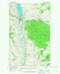
1957 Map of Oroville
USGS Topo · Published 1967About this map
Osoyoos Lake straddles the international boundary between Washington and British Columbia, anchoring this 1957 field-checked survey of the northern Okanogan Valley. The settlement of Oroville serves as the regional hub at the confluence of the Similkameen River and the Okanogan River. The landscape reflects a diverse mid-century economy, where the Great Northern River rail line follows the valley floor, supporting agricultural transport and local industry. To the west, the arid Whitestone Flats and Whitestone Lake are serviced by irrigation infrastructure like the Whisky Mtn Flume. Eastward, the terrain rises sharply into the Okanogan National Forest, where features such as Mt Hull and Haley Canyon dominate the topography. Local history is evidenced by the Cem near Oroville and the Lucky Knock Mine in the southwest, indicating the area's mining and pioneering heritage.
Find a feature on this map
60 named features on this map. Tap any name to fly to it.
Don’t see what you’re looking for? This feature index may not catch every label — zoom into the map to look around manually.
Map Details
Editions of this 1957 Oroville Map
3 editions found
Other maps of this area

1902 · Osoyoos
USGS Topo · 1:125,000

1904 · Osoyoos
USGS Topo · 1:125,000

1906 · Chopaka
USGS Topo · 1:125,000

1954 · Okanogan
USGS Topo · 1:250,000

1956 · Loomis
USGS Topo · 1:62,500

1957 · Conconully
USGS Topo · 1:62,500

1957 · Mt. Bonaparte
USGS Topo · 1:62,500

1957 · Tonasket
USGS Topo · 1:62,500

1957 · Oroville
USGS Topo · 1:62,500

1957 · Aeneas Valley
USGS Topo · 1:62,500