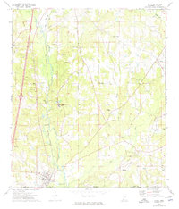
1972 Map of Osyka
USGS Topo · Published 1974About this map
The Illinois Central Gulf River corridor defines the landscape of the Mississippi-Louisiana borderlands in the early 1970s. Running parallel to the Tangipahoa River, this vital transit line links the settled community of Osyka with the distinctive educational and religious enclave at Chatawa. This northern reach of the parish line features the St Mary of the Pines Academy and the Chatawa Mission, marking the area as a significant center for regional institutional history.
Find a feature on this map
27 named features on this map. Tap any name to fly to it.
Don’t see what you’re looking for? This feature index may not catch every label — zoom into the map to look around manually.
Map Details
Editions of this 1972 Osyka Map
This is the sole edition of this map. No revisions or reprints were ever made.
Other maps of this area

1939 · Sunny Hill
USGS Topo · 1:31,680

1940 · Spring Creek
USGS Topo · 1:31,680

1950 · Kentwood
USGS Topo · 1:31,680

1953 · Natchez
USGS Topo · 1:250,000

1954 · Baton Rouge
USGS Topo · 1:250,000

1956 · Natchez
USGS Topo · 1:250,000

1956 · Baton Rouge
USGS Topo · 1:250,000
1958 · Kentwood
USGS Topo · 1:62,500
1958 · Mount Hermon
USGS Topo · 1:62,500

1959 · Natchez
USGS Topo · 1:250,000