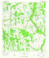
1953 Map of Oviedo SW
USGS Topo · Published 1964About this map
The Econlockhatchee River and its western tributary, the Little Econlockhatchee River, weave through this eastern Florida landscape during a period of transition between rural orange groves and early suburban expansion. The survey documents a wet terrain punctuated by dozens of named water bodies, including Lake Georgia, Lake Rouse, and Lake Tanner. Along the Cheney Highway, the small settlement of Bithlo and its surrounding community landmarks like Lockwood Ch provide a window into the mid-century social fabric of Orange County.
Find a feature on this map
26 named features on this map. Tap any name to fly to it.
Don’t see what you’re looking for? This feature index may not catch every label — zoom into the map to look around manually.
Map Details
Editions of this 1953 Oviedo SW Map
4 editions found
Other maps of this area

1953 · Narcoossee NE
USGS Topo · 1:24,000

1953 · Pine Castle
USGS Topo · 1:24,000

1953 · Geneva
USGS Topo · 1:24,000

1953 · Oviedo SW
USGS Topo · 1:24,000

1953 · Narcoossee NW
USGS Topo · 1:24,000

1953 · Bithlo
USGS Topo · 1:24,000

1955 · Orlando
USGS Topo · 1:250,000

1956 · Oviedo
USGS Topo · 1:24,000

1956 · Orlando East
USGS Topo · 1:24,000

1957 · Orlando
USGS Topo · 1:250,000