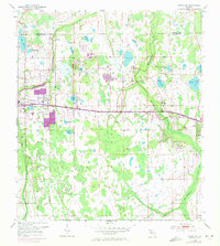
1953 Map of Oviedo SW
USGS Topo · Published 1972About this map
The Little Econlockhatchee River and its larger counterpart, the Econlockhatchee River, define the hydrology of this East Orange County landscape as it transitioned in the mid-20th century. While much of the eastern portion of the sheet remains dominated by wetlands and cypress strands, the western edge shows the early residential footprint of Union Park, complete with the Union Park Sch and Downey Ch. The map captures the alignment of the Cheney Highway as it cuts across the center, linking the suburbanizing fringe with more isolated settlements like Bithlo and Cheney. Genealogists and local historians can locate the Rouse Cem near Lake Rouse, a key landmark amongst a density of water bodies that includes Lake Price, Lake Kehoe, and Lake Drawdy. Revisions from 1970 reveal more recent development patterns, such as a Drive-in Theater and expanded urban areas near the Seminole Co Orange Co boundary.
Find a feature on this map
27 named features on this map. Tap any name to fly to it.
Don’t see what you’re looking for? This feature index may not catch every label — zoom into the map to look around manually.
Map Details
Editions of this 1953 Oviedo SW Map
4 editions found
Other maps of this area

1953 · Narcoossee NE
USGS Topo · 1:24,000

1953 · Pine Castle
USGS Topo · 1:24,000

1953 · Geneva
USGS Topo · 1:24,000

1953 · Oviedo SW
USGS Topo · 1:24,000

1953 · Narcoossee NW
USGS Topo · 1:24,000

1953 · Bithlo
USGS Topo · 1:24,000

1955 · Orlando
USGS Topo · 1:250,000

1956 · Oviedo
USGS Topo · 1:24,000

1956 · Orlando East
USGS Topo · 1:24,000

1957 · Orlando
USGS Topo · 1:250,000