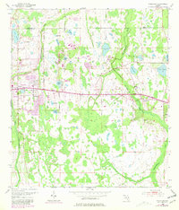
1953 Map of Oviedo SW
USGS Topo · Published 1981About this map
The Econlockhatchee River and its western tributary, the Little Econlockhatchee River, dominate this landscape east of Orlando during the early 1950s. The map illustrates a transitional period of rural land use, where family names are tied to the land via landmarks like Rouse Cem and Lake Rouse. The east-west corridor of Cheney Highway serves as the primary artery, connecting the developing settlement at Union Park to the outlying community of Bithlo. Cultural revisions from the late 1970s, shown in purple, reveal the initial expansion of residential footprints and the addition of a Drive-in Theater near the Union Park Sch. Local spiritual and educational life is anchored by Downey Ch and Lockwood Ch, while dozens of small water bodies like Lake Price and Lake Georgia punctuate the flat, low-lying terrain of eastern Orange County.
Find a feature on this map
29 named features on this map. Tap any name to fly to it.
Don’t see what you’re looking for? This feature index may not catch every label — zoom into the map to look around manually.
Map Details
Editions of this 1953 Oviedo SW Map
4 editions found
Other maps of this area

1953 · Narcoossee NE
USGS Topo · 1:24,000

1953 · Pine Castle
USGS Topo · 1:24,000

1953 · Geneva
USGS Topo · 1:24,000

1953 · Oviedo SW
USGS Topo · 1:24,000

1953 · Narcoossee NW
USGS Topo · 1:24,000

1953 · Bithlo
USGS Topo · 1:24,000

1955 · Orlando
USGS Topo · 1:250,000

1956 · Oviedo
USGS Topo · 1:24,000

1956 · Orlando East
USGS Topo · 1:24,000

1957 · Orlando
USGS Topo · 1:250,000