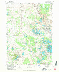
1968 Map of Oxford
USGS Topo · Published 1971About this map
Glacial lakes and rolling topography define this Oakland County landscape during the late 1960s, a period of transition between its agricultural roots and growing residential character. The village of Oxford serves as a central hub, where the G T W and Penn Central railroads intersect, supporting a local economy historically tied to extensive Gravel Pits. Educational and religious institutions are prominent landmarks, including St Josephs Convent and DeLima College near Duck Lake.
Find a feature on this map
89 named features on this map. Tap any name to fly to it.
Don’t see what you’re looking for? This feature index may not catch every label — zoom into the map to look around manually.
Map Details
Editions of this 1968 Oxford Map
Other maps of this area

1907 · Pontiac
USGS Topo · 1:62,500

1908 · Rochester
USGS Topo · 1:62,500

1936 · Clarkston
USGS Topo · 1:31,680

1936 · Rochester
USGS Topo · 1:31,680

1936 · Pontiac North
USGS Topo · 1:31,680

1943 · Clarkston
USGS Topo · 1:24,000

1943 · Pontiac North
USGS Topo · 1:24,000

1943 · Ortonville
USGS Topo · 1:24,000

1943 · Lake Orion
USGS Topo · 1:24,000

1943 · Oxford
USGS Topo · 1:24,000
Featured Places
- Orion Charter Township, MI
- Independence Charter Township, MI
- Oxford Charter Township, MI
- Oxford, MI
- Lake Orion, MI