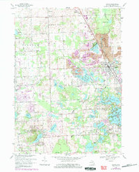
1968 Map of Oxford
USGS Topo · Published 1984About this map
Glacial lakes and gravel extraction define the landscape of northern Oakland County during this mid-century period. The village of Oxford serves as a central hub, where the Grand Trunk Western Railroad intersects with a network of local routes like Seymour Lake Road and Indianwood Road. The map reveals a dense concentration of water bodies, including Lake Orion, Stony Lake, and Tan Lake, many of which are surrounded by growing residential clusters like Lake Orion Heights. Significant land use transitions are evident in the numerous gravel pits and a designated reclaimed area near Seymour Lake. Cultural landmarks such as DeLima College, St Josephs Convent, and Camp Agawam sit alongside established local institutions like the Seymour Lake Ch and Oakwood Cem, providing a detailed look at the community's social and religious foundations.
Find a feature on this map
82 named features on this map. Tap any name to fly to it.
Don’t see what you’re looking for? This feature index may not catch every label — zoom into the map to look around manually.
Map Details
Editions of this 1968 Oxford Map
Other maps of this area

1907 · Pontiac
USGS Topo · 1:62,500

1908 · Rochester
USGS Topo · 1:62,500

1936 · Clarkston
USGS Topo · 1:31,680

1936 · Rochester
USGS Topo · 1:31,680

1936 · Pontiac North
USGS Topo · 1:31,680

1943 · Clarkston
USGS Topo · 1:24,000

1943 · Pontiac North
USGS Topo · 1:24,000

1943 · Ortonville
USGS Topo · 1:24,000

1943 · Lake Orion
USGS Topo · 1:24,000

1943 · Oxford
USGS Topo · 1:24,000
Featured Places
- Orion Charter Township, MI
- Independence Charter Township, MI
- Oxford Charter Township, MI
- Oxford, MI
- Lake Orion, MI