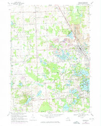
1968 Map of Oxford
USGS Topo · Published 1974About this map
Glacial lakes and gravel extraction define the landscape of northern Oakland County during this late-1960s survey. The village of Oxford serves as a central hub, situated where the Gtw and Penn Central railroads intersect. To the north, the small settlement of Oakwood remains largely rural, while the southern reaches near Lake Orion Heights and Bellevue show increasing suburban density. The topography is dotted with dozens of water bodies, from the sprawling Indianwood Lake to smaller basins like Tan Lake and Squaw Lake.
Find a feature on this map
78 named features on this map. Tap any name to fly to it.
Don’t see what you’re looking for? This feature index may not catch every label — zoom into the map to look around manually.
Map Details
Editions of this 1968 Oxford Map
Other maps of this area

1907 · Pontiac
USGS Topo · 1:62,500

1908 · Rochester
USGS Topo · 1:62,500

1936 · Clarkston
USGS Topo · 1:31,680

1936 · Rochester
USGS Topo · 1:31,680

1936 · Pontiac North
USGS Topo · 1:31,680

1943 · Clarkston
USGS Topo · 1:24,000

1943 · Pontiac North
USGS Topo · 1:24,000

1943 · Ortonville
USGS Topo · 1:24,000

1943 · Lake Orion
USGS Topo · 1:24,000

1943 · Oxford
USGS Topo · 1:24,000
Featured Places
- Orion Charter Township, MI
- Independence Charter Township, MI
- Oxford Charter Township, MI
- Oxford, MI
- Lake Orion, MI