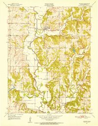
1951 Map of Ozawkie
USGS Topo · Published 1952About this map
Delaware River meanders through the heart of Jefferson County in this early 1950s survey, defining a landscape shaped by historical boundaries and rural education. The map preserves the original location of Ozawkie before the subsequent construction of Perry Lake, showing it as a compact river town at the junction of the Delaware River and Rock Creek. Significant local history is captured in the network of one-room schools that once dotted the townships, including Hayes Sch, Lowry Sch, and Pleasant Valley Sch, alongside several already noted as Kilgour Sch (Abandoned) and Ross Sch (Abandoned). The legacy of the Old Delaware Reservation is clearly marked across the terrain, alongside community landmarks like Liberty Ch and Olive Branch Cem. This record provides a detailed look at the agricultural and social structure of the Kansas river valley at mid-century.
Find a feature on this map
24 named features on this map. Tap any name to fly to it.
Don’t see what you’re looking for? This feature index may not catch every label — zoom into the map to look around manually.
Map Details
Editions of this 1951 Ozawkie Map
5 editions found

Other maps of this area

1886 · Oskaloosa
USGS Topo · 1:125,000

1888 · Oskaloosa
USGS Topo · 1:125,000

1889 · Topeka
USGS Topo · 1:125,000

1894 · Oskaloosa
USGS Topo · 1:125,000

1894 · Topeka
USGS Topo · 1:125,000

1949 · Williamstown
USGS Topo · 1:24,000

1949 · Perry
USGS Topo · 1:24,000

1950 · Perry
USGS Topo · 1:24,000

1950 · Kansas City
USGS Topo · 1:250,000

1950 · Williamstown
USGS Topo · 1:24,000