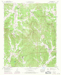
1950 Map of Paden
USGS Topo · Published 1971About this map
Paden sits at the crossing of the Illinois Central Railroad and Mackeys Creek, serving as a central hub in this corner of Tishomingo County. The landscape is defined by the Tennessee Valley Divide, which separates the headwaters of Yellow Creek and Clausel Creek to the north from the southern drainage of Hurricane Creek and Mackeys Creek. This 1950s record, updated with 1969 revisions, shows the rural community structure before the modern expansion of the Natchez Trace Parkway. Numerous community landmarks, including the New Lebanon Church, Forked Oak Church, and Clausel Hill Church, are preserved here alongside family burial grounds like the Stephens Cem and Belue Cem. The presence of Pollard Mill Creek and scattered schools like Lambert Chapel suggests a local economy and social life deeply rooted in the creeks and crossroads of the Mississippi hills.
Find a feature on this map
45 named features on this map. Tap any name to fly to it.
Don’t see what you’re looking for? This feature index may not catch every label — zoom into the map to look around manually.
Map Details
Editions of this 1950 Paden Map
3 editions found
Other maps of this area

1911 · Iuka
USGS Topo · 1:48,000

1914 · Iuka
USGS Topo · 1:62,500

1935 · Holcut
USGS Topo · 1:24,000

1935 · Iuka
USGS Topo · 1:24,000

1935 · Leedy
USGS Topo · 1:24,000

1935 · Glens
USGS Topo · 1:24,000

1936 · Belmont
USGS Topo · 1:24,000

1936 · Tishomingo
USGS Topo · 1:24,000

1950 · Paden
USGS Topo · 1:24,000
1950 · Burnsville
USGS Topo · 1:24,000