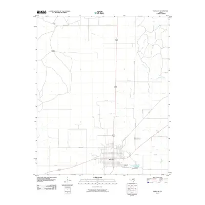
2010 Map of Paducah
USGS Topo · Published 2010About this map
Paducah sits at the intersection of several regional ranch roads in this 2010 survey of the Cottle County seat. The street grid is well-defined, bounded to the south by the Garden of Memories cemetery and the Paducah Golf Club Lake. To the northeast, the landscape is shaped by the winding paths of Owl Creek and Shorty Creek, which contrast with the straight-line ranch roads that dominate the western portion of the quadrangle. Distinctive agricultural and industrial landmarks, such as the O X Trap Windmill and Fairberry Windmill, reflect the area's rural character, while the Dan E Richards Municipal Airport northeast of the town center marks the transition to modern infrastructure. This map captures the relationship between the concentrated municipal center and the surrounding expansive ranchland typical of West Texas.
Find a feature on this map
32 named features on this map. Tap any name to fly to it.
Don’t see what you’re looking for? This feature index may not catch every label — zoom into the map to look around manually.
Map Details
Editions of this 2010 Paducah Map
This is the sole edition of this map. No revisions or reprints were ever made.
Other maps of this area

1954 · Lubbock
USGS Topo · 1:250,000

1954 · Plainview
USGS Topo · 1:250,000

1958 · Plainview
USGS Topo · 1:250,000

1966 · Cee Vee
USGS Topo · 1:24,000

1966 · Devils Canyon
USGS Topo · 1:24,000

1967 · Dunlap
USGS Topo · 1:24,000

1967 · Paducah
USGS Topo · 1:24,000

1967 · Moons Camp
USGS Topo · 1:24,000
1967 · Swearingen
USGS Topo · 1:24,000
1968 · Chalk
USGS Topo · 1:24,000