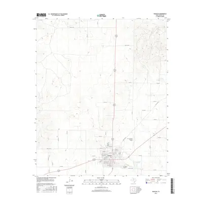
2016 Map of Paducah
USGS Topo · Published 2016About this map
Paducah serves as the focal point of this Cottle County survey, sitting at the junction of several regional ranch roads and highway routes. The town grid is clearly defined, extending south toward the Garden of Memories Cem and Ranch Rd 1038. The surrounding landscape is characterized by a network of intermittent drainage features, including Ox Cr, Owl Cr, and Shorty Cr, which carve through the terrain of the Texas Rolling Plains. These natural waterways dictate the placement of the various county and ranch-to-market roads that serve the local cattle and agricultural economy. Aviation and recreation also mark the local geography, evidenced by the Dan E Richards Municipal Airport northeast of the main town site and the Paducah Golf Club Lake situated to the east.
Find a feature on this map
49 named features on this map. Tap any name to fly to it.
Don’t see what you’re looking for? This feature index may not catch every label — zoom into the map to look around manually.
Map Details
Editions of this 2016 Paducah Map
This is the sole edition of this map. No revisions or reprints were ever made.
Other maps of this area

1954 · Lubbock
USGS Topo · 1:250,000

1954 · Plainview
USGS Topo · 1:250,000

1958 · Plainview
USGS Topo · 1:250,000

1966 · Cee Vee
USGS Topo · 1:24,000

1966 · Devils Canyon
USGS Topo · 1:24,000

1967 · Dunlap
USGS Topo · 1:24,000

1967 · Paducah
USGS Topo · 1:24,000

1967 · Moons Camp
USGS Topo · 1:24,000
1967 · Swearingen
USGS Topo · 1:24,000
1968 · Chalk
USGS Topo · 1:24,000