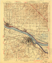
1929 Map of Paducah
USGS Topo · Published 1942About this map
The Ohio River and Tennessee River converge at a critical junction in this early twentieth-century landscape, where river traffic met the iron rails of the Illinois Central RR. On the Kentucky side, Paducah is shown as a developed urban hub with neighborhoods like Evandale Heights and Woodlawn expanding southward. Across the water in Illinois, Metropolis and Brookport serve as key riverfront entries, with the historical grounds of Fort Massac State Park preserved on the shoreline. This era shows a countryside dense with small community landmarks, including numerous rural schools like Round Spring Sch and Klondike Sch, and local institutions such as the County Sanitarium. The map details the complex drainage of the Black Bottom region, where islands like Owens Island and backwater lakes such as Allard Lake reveal the original hydrology of the floodplain before modern river management significantly altered the riverbanks.
Find a feature on this map
105 named features on this map. Tap any name to fly to it.
Don’t see what you’re looking for? This feature index may not catch every label — zoom into the map to look around manually.
Map Details
Editions of this 1929 Paducah Map
4 editions found
Other maps of this area

1916 · Golconda
USGS Topo · 1:62,500

1917 · Brownfield
USGS Topo · 1:62,500

1918 · Vienna
USGS Topo · 1:62,500

1919 · Vienna
USGS Topo · 1:62,500

1920 · Goloonda
USGS Topo · 1:48,000

1921 · Golconda
USGS Topo · 1:62,500

1926 · Paducah
USGS Topo · 1:62,500

1928 · La Center
USGS Topo · 1:62,500

1929 · Smithland
USGS Topo · 1:62,500

1929 · Paducah
USGS Topo · 1:62,500