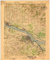
1929 Map of Paducah
USGS Topo · Published 1929About this map
Paducah and its industrial riverfront dominate this 1920s survey of the confluence of the Ohio River and the Tennessee River. The street grid of the city expands toward Evandale Heights, while the Illinois Central Railroad infrastructure defines the urban transportation corridor. Across the water, the Illinois shoreline features the riverside settlements of Metropolis and Brookport, connected by the early transit patterns of the era. The rural landscape of McCracken County is densely marked by community institutions such as Palestine Ch, Hamilton Chapel, and numerous schools like Hendron Sch. Notably, the map records the County Sanitarium and local burial grounds including Meyer Cemetery, providing significant detail for genealogists tracing family roots in the Jackson Purchase region. Terrain features like Owens Island and the bottomlands of Black Bottom illustrate the influence of the river systems on the local geography.
Find a feature on this map
103 named features on this map. Tap any name to fly to it.
Don’t see what you’re looking for? This feature index may not catch every label — zoom into the map to look around manually.
Map Details
Editions of this 1929 Paducah Map
4 editions found
Other maps of this area

1916 · Golconda
USGS Topo · 1:62,500

1917 · Brownfield
USGS Topo · 1:62,500

1918 · Vienna
USGS Topo · 1:62,500

1919 · Vienna
USGS Topo · 1:62,500

1920 · Goloonda
USGS Topo · 1:48,000

1921 · Golconda
USGS Topo · 1:62,500

1926 · Paducah
USGS Topo · 1:62,500

1928 · La Center
USGS Topo · 1:62,500

1929 · Smithland
USGS Topo · 1:62,500

1929 · Paducah
USGS Topo · 1:62,500