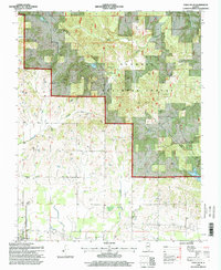
1996 Map of Paducah NE
USGS Topo · Published 1998About this map
The southern reaches of the Shawnee National Forest dominate the northern half of this landscape, where the wooded hills of Massac and Pope counties meet the flatter lowlands toward the Ohio River. Settlement patterns here are defined by small agricultural holdings and numerous family or community burial grounds, including the Buzzard Roost Cem, Sycamore Plain Cem, and Masonic Cem. These sites, along with rural landmarks like Mt Pleasant Ch and Waldo Ch, reveal the social fabric of the countryside in the mid-1990s. Near the southern border, the town of Brookport serves as a local hub, situated near drainage systems like Sevenmile Creek and Crenshaw Creek. This survey records a transition from the managed timberlands and creeks of the interior, such as Dog Creek and Barren Creek, to the more developed agricultural and residential areas surrounding the riverfront corridor.
Find a feature on this map
39 named features on this map. Tap any name to fly to it.
Don’t see what you’re looking for? This feature index may not catch every label — zoom into the map to look around manually.
Map Details
Editions of this 1996 Paducah NE Map
2 editions found
Other maps of this area

1916 · Golconda
USGS Topo · 1:62,500

1917 · Brownfield
USGS Topo · 1:62,500

1920 · Goloonda
USGS Topo · 1:48,000

1921 · Golconda
USGS Topo · 1:62,500

1926 · Paducah
USGS Topo · 1:62,500

1929 · Smithland
USGS Topo · 1:62,500

1929 · Paducah
USGS Topo · 1:62,500

1936 · Paducah
USGS Topo · 1:24,000

1936 · Smithland
USGS Topo · 1:48,000

1936 · Little Cypress
USGS Topo · 1:24,000