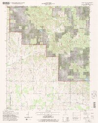
1996 Map of Paducah NE
USGS Topo · Published 1998About this map
Brookport and the surrounding farmland of southern Illinois are documented here during the late 20th century, revealing a landscape defined by small-town life and rural institutions. The northern portion of the map is dominated by the Shawnee National Forest, where steep, wooded drainages like Burke Creek and Barren Creek cut through the hills. This upland area is dotted with numerous family and community burial grounds, including the Sycamore Plain Cem, Golightly Cem, and Roe Cem, many of which sit near historic congregations like Azotus Ch.
Find a feature on this map
43 named features on this map. Tap any name to fly to it.
Don’t see what you’re looking for? This feature index may not catch every label — zoom into the map to look around manually.
Map Details
Editions of this 1996 Paducah NE Map
2 editions found
Other maps of this area

1916 · Golconda
USGS Topo · 1:62,500

1917 · Brownfield
USGS Topo · 1:62,500

1920 · Goloonda
USGS Topo · 1:48,000

1921 · Golconda
USGS Topo · 1:62,500

1926 · Paducah
USGS Topo · 1:62,500

1929 · Smithland
USGS Topo · 1:62,500

1929 · Paducah
USGS Topo · 1:62,500

1936 · Paducah
USGS Topo · 1:24,000

1936 · Smithland
USGS Topo · 1:48,000

1936 · Little Cypress
USGS Topo · 1:24,000