
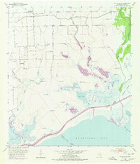
1952 Map of Palacios NE
USGS Topo · Published 1953About this map
The low-lying wetlands of Matagorda County meet the Matagorda Bay coastline in this early 1950s study. The landscape is dominated by complex water systems, including the long reaches of Robbins Slough and Little Robbins Slough, which drain toward the coast. Human modification of the terrain is evident in the extensive Levee networks protecting inland areas and the straight-cut path of the Intracoastal Waterway slicing through the marsh near Crab Lake and Freshwater Lake.
Find a feature on this map
29 named features on this map. Tap any name to fly to it.
Don’t see what you’re looking for? This feature index may not catch every label — zoom into the map to look around manually.
Map Details
Editions of this 1952 Palacios NE Map
2 editions found
Other maps of this area

1951 · Bay City
USGS Topo · 1:250,000

1952 · Palacios SE
USGS Topo · 1:24,000

1952 · Palacios Point
USGS Topo · 1:24,000

1952 · Matagorda
USGS Topo · 1:24,000

1952 · Blessing SE
USGS Topo · 1:24,000

1952 · Palacios
USGS Topo · 1:24,000
1952 · Matagorda SW
USGS Topo · 1:24,000

1952 · Blessing
USGS Topo · 1:24,000

1952 · Wadsworth
USGS Topo · 1:24,000

1953 · Beeville
USGS Topo · 1:250,000