
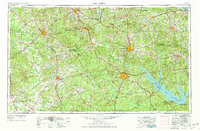
1953 Map of Palestine
USGS Topo · Published 1964About this map
The Trinity River and Neches River define the winding, forested topography of this East Texas region during the mid-twentieth century. Major rail networks, including the Missouri Pacific RR and Southern Pacific RR, anchor established centers like Palestine, Nacogdoches, and Lufkin. The era's industrial footprint is visible through extensive energy production at the Cayuga Oil Field and Long Lake Oil Field in the west. Conservation and recreation are represented by the sprawling boundaries of the Davy Crockett National Forest and Angelina National Forest. One significant geographical change is noted with the Sam Rayburn Reservoir, which is shown as an area to be submerged, marking a transition in the valley of the Angelina River as major water management projects began to reshape the local landscape.
Find a feature on this map
132 named features on this map. Tap any name to fly to it.
Don’t see what you’re looking for? This feature index may not catch every label — zoom into the map to look around manually.
Map Details
Editions of this 1953 Palestine Map
2 editions found
Other maps of this area

1919 · Fairfield
USGS Topo · 1:62,500

1927 · Lufkin 4-c
USGS Topo · 1:24,000

1928 · Zavalla 3-c
USGS Topo · 1:24,000

1928 · Lufkin 4-d
USGS Topo · 1:24,000

1931 · Zavalla
USGS Topo · 1:62,500

1931 · Iola
USGS Topo · 1:62,500

1932 · Manning
USGS Topo · 1:62,500

1935 · Henderson
USGS Topo · 1:48,000

1937 · Troupe
USGS Topo · 1:48,000

1939 · Henderson
USGS Topo · 1:62,500