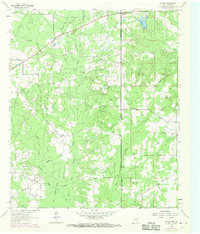
1962 Map of Panola
USGS Topo · Published 1969About this map
Bethany and Panola sit at the intersection of industry and statehood in this mid-century survey of the Texas and Louisiana borderlands. The landscape is defined by the hydrologic network of Socagee Creek, including its East Fork and West Fork tributaries, which drain south toward Mill Creek. The map records an era of transition for rural infrastructure, where the Old Railroad Grade remains visible alongside a modern network of pipelines and extraction sites, including numerous oil wells and gas wells.
Find a feature on this map
28 named features on this map. Tap any name to fly to it.
Don’t see what you’re looking for? This feature index may not catch every label — zoom into the map to look around manually.
Map Details
Editions of this 1962 Panola Map
Other maps of this area

1943 · Waskom
USGS Topo · 1:62,500

1945 · Grand Cane
USGS Topo · 1:62,500

1945 · Waskom
USGS Topo · 1:62,500

1945 · Greenwood
USGS Topo · 1:62,500

1945 · Socagee Bayou
USGS Topo · 1:62,500

1955 · Shreveport
USGS Topo · 1:250,000

1955 · Greenwood
USGS Topo · 1:62,500

1956 · Shreveport
USGS Topo · 1:250,000

1956 · Tyler
USGS Topo · 1:250,000

1956 · Deadwood
USGS Topo · 1:62,500