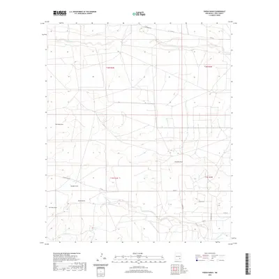
2020 Map of Parish Ranch
USGS Topo · Published 2020About this map
Parish Ranch serves as a primary landmark in this corner of Eddy County, where the high desert landscape is defined by an intricate network of drainage systems. The northern portion of the quadrangle is bisected by the Rio Peñasco, while the southern reaches are marked by the seasonal flows of North Seven Rivers. This 2020 survey illustrates the remote character of the region, emphasizing the importance of isolated water sources like Hoag Tank. Local topography is characterized by several named erosional features, including Red Tank Draw, Fourmile Draw, and Cat Claw Draw. The map documents a sparse road network essential for ranching access, featuring routes such as W Four Dinkus Rd, Rocking 8 Red Rd, and Cross Buck Rd, which navigate the township and range boundaries of T18S and T19S.
Find a feature on this map
22 named features on this map. Tap any name to fly to it.
Don’t see what you’re looking for? This feature index may not catch every label — zoom into the map to look around manually.
Map Details
Editions of this 2020 Parish Ranch Map
This is the sole edition of this map. No revisions or reprints were ever made.
Other maps of this area

1954 · Seven Rivers
USGS Topo · 1:24,000

1954 · Carlsbad
USGS Topo · 1:250,000

1955 · Artesia
USGS Topo · 1:24,000

1955 · Dayton
USGS Topo · 1:24,000

1955 · Hope
USGS Topo · 1:24,000

1956 · Hope
USGS Topo · 1:24,000

1956 · Parish Ranch
USGS Topo · 1:24,000

1956 · Antelope Sink
USGS Topo · 1:24,000

1956 · Hope SE
USGS Topo · 1:24,000

1957 · Foster Ranch
USGS Topo · 1:24,000