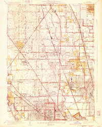
1929 Map of Park Ridge
USGS Topo · Published 1929About this map
The North Branch Chicago River and the Des Plaines River define the drainage of this developing suburban landscape in the late 1920s. Established townships like Northfield, Maine, and Niles are transitioning from rural school districts, such as Maple School and West Northfield School, into organized residential hubs. The map reveals an extensive network of recreational and institutional land use, with numerous golf clubs including the Bunker Hill Country Club and the Glenview Country Club interspersed with religious and charitable sites like the Croatian Orphanage and St Marys Mission House. Heavy rail transit, anchored by the Chicago and Northwestern Railroad, connects established centers like Park Ridge and Morton Grove to the expanding metropolis of Chicago to the south.
Find a feature on this map
89 named features on this map. Tap any name to fly to it.
Don’t see what you’re looking for? This feature index may not catch every label — zoom into the map to look around manually.
Map Details
Editions of this 1929 Park Ridge Map
3 editions found

Other maps of this area

1889 · Chicago
USGS Topo · 1:62,500

1891 · Chicago
USGS Topo · 1:62,500

1891 · Riverside
USGS Topo · 1:62,500

1893 · Riverside
USGS Topo · 1:62,500

1899 · Evanston
USGS Topo · 1:62,500

1900 · Chicago
USGS Topo · 1:62,500

1900 · Riverside
USGS Topo · 1:62,500

1900 · Highwood
USGS Topo · 1:62,500

1901 · Riverside
USGS Topo · 1:62,500

1901 · Chicago
USGS Topo · 1:62,500