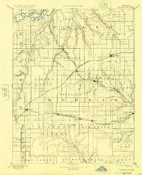
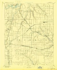
1894 Map of Parkerville
USGS Topo · Published 1925About this map
The Neosho River and the Smoky Hill River define this portion of the Kansas landscape, which was surveyed by E.T. Perkins Jr. during a period of rapid railroad expansion. The map illustrates a developed network of iron rails, including the Kansas and Texas Railroad and the Topeka Salina and Western Railroad, which connected rising agricultural centers like Council Grove and White City. These rail lines were essential to the economy of the Rolling Prairie, moving grain and livestock from regional hubs such as Herington and Wilsey. Smaller settlements like Skiddy, Dwight, and Parkerville appear as vital nodes within this transit-dependent network. The terrain is characterized by numerous drainage systems, including Clarks Creek and Lyon Creek, which influenced the placement of early townships and transportation corridors during the late nineteenth century.
Find a feature on this map
74 named features on this map. Tap any name to fly to it.
Don’t see what you’re looking for? This feature index may not catch every label — zoom into the map to look around manually.
Map Details
Editions of this 1894 Parkerville Map
6 editions found

Other maps of this area

1885 · Eskridge
USGS Topo · 1:125,000

1886 · Junction City
USGS Topo · 1:125,000

1888 · Emporia
USGS Topo · 1:125,000

1889 · Newton
USGS Topo · 1:125,000

1889 · Wamego
USGS Topo · 1:125,000

1889 · Junction City
USGS Topo · 1:125,000

1889 · Abilene
USGS Topo · 1:125,000

1889 · Parkerville
USGS Topo · 1:125,000

1889 · Eskridge
USGS Topo · 1:125,000

1891 · Clay Center
USGS Topo · 1:125,000