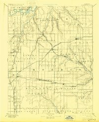
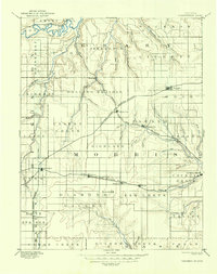
1894 Map of Parkerville
USGS Topo · Published 1930About this map
Council Grove serves as the eastern anchor for this landscape, which is defined by the headwaters of several major waterways including the Neosho River and Smoky Hill River. Surveyed in the late 19th century, the area shows a maturing agricultural frontier where the Rolling Prairie is increasingly subdivided by a dense network of competing rail lines. The Kansas and Texas Railroad passes through Parkerville, while the Topeka Salina and Western Railroad links smaller sidings like Patterson and Wilsey. Small settlements such as White City and Dwight emerged as vital shipping points during this period of expansion. The map also captures numerous tributary creeks like Six Mile Creek and Clarkes Creek, which dictated the initial settlement patterns and township boundaries across the Highland terrain.
Find a feature on this map
67 named features on this map. Tap any name to fly to it.
Don’t see what you’re looking for? This feature index may not catch every label — zoom into the map to look around manually.
Map Details
Editions of this 1894 Parkerville Map
6 editions found

Other maps of this area

1885 · Eskridge
USGS Topo · 1:125,000

1886 · Junction City
USGS Topo · 1:125,000

1888 · Emporia
USGS Topo · 1:125,000

1889 · Newton
USGS Topo · 1:125,000

1889 · Wamego
USGS Topo · 1:125,000

1889 · Junction City
USGS Topo · 1:125,000

1889 · Abilene
USGS Topo · 1:125,000

1889 · Parkerville
USGS Topo · 1:125,000

1889 · Eskridge
USGS Topo · 1:125,000

1891 · Clay Center
USGS Topo · 1:125,000