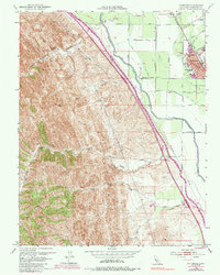
1953 Map of Patterson
USGS Topo · Published 1985About this map
Patterson serves as the focal point of this Central Valley survey, showcasing a landscape transitioning from the rugged canyons of the Diablo Range to intensive irrigated agriculture. The map illustrates the sophisticated water infrastructure essential to the region, featuring the California Aqueduct and the Delta-Mendota Canal running parallel to the foothills. These massive projects contrast with the natural drainages of Del Puerto Creek and Salado Creek.
Find a feature on this map
43 named features on this map. Tap any name to fly to it.
Don’t see what you’re looking for? This feature index may not catch every label — zoom into the map to look around manually.
Map Details
Editions of this 1953 Patterson Map
4 editions found
Other maps of this area

1913 · Romain
USGS Topo · 1:31,680

1915 · Westport
USGS Topo · 1:31,680

1915 · Westley
USGS Topo · 1:31,680

1916 · Crows Landing
USGS Topo · 1:31,680

1916 · Patterson
USGS Topo · 1:31,680

1916 · Romain
USGS Topo · 1:31,680

1917 · Newman
USGS Topo · 1:31,680

1919 · Orestimba
USGS Topo · 1:62,500

1919 · Orestimba Creek
USGS Topo · 1:31,680

1922 · Carbona
USGS Topo · 1:62,500