
1954 Map of Pecos
USGS Topo · Published 1964About this map
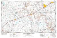
The Pecos River carves a winding path through this West Texas landscape, serving as the central artery for a region defined by high-desert hydrology and petroleum extraction. By the mid-1950s, the terrain is marked by an extensive network of windmills and underground pipelines, particularly around burgeoning centers like Odessa and Kermit. The map illustrates the historical reliance on vital water sources such as Red Bluff Lake, Santa Rosa Spring, and Zimmerman Reservoir to support ranching operations like Goodrich Ranch and Robinson Ranch.
Find a feature on this map
94 named features on this map. Tap any name to fly to it.
Don’t see what you’re looking for? This feature index may not catch every label — zoom into the map to look around manually.
Map Details
Editions of this 1954 Pecos Map
3 editions found
Other maps of this area

1894 · Valentine
USGS Topo · 1:125,000

1894 · Fort Davis
USGS Topo · 1:125,000

1897 · Valentine
USGS Topo · 1:125,000

1897 · Fort Davis
USGS Topo · 1:125,000

1921 · Toyah
USGS Topo · 1:125,000

1921 · Fort Stockton
USGS Topo · 1:62,500

1923 · Fort Stockton
USGS Topo · 1:62,500

1925 · Orla 2-b
USGS Topo · 1:48,000

1928 · Crane
USGS Topo · 1:125,000

1928 · Kent
USGS Topo · 1:125,000