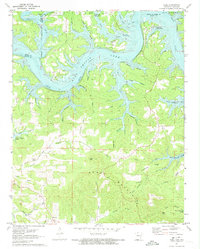
1972 Map of Peel
USGS Topo · Published 1973About this map
Bull Shoals Lake dominates the landscape along the state line where Taney and Marion counties meet. This survey, completed in the early 1970s, illustrates the complex shoreline of the reservoir, which submerged the original river valley at Elevation 654. The Peel Ferry remains a critical transportation link across the White River arm of the lake, connecting the community of Peel to the north. Historical land use is visible through family-named landmarks like Riddle Cem and Upshaw Cem, while the industrial past is marked by a Lead Mine near Short Mountain. The terrain transitions from the inundated valleys to high points like Jap Knob and Gay Ridge, reflecting the topographic character of the Ozarks before further modern development. These records of the lake's early decades are vital for tracing road networks and settlements like Monarch that shaped local commerce.
Find a feature on this map
65 named features on this map. Tap any name to fly to it.
Don’t see what you’re looking for? This feature index may not catch every label — zoom into the map to look around manually.
Map Details
Editions of this 1972 Peel Map
2 editions found
Other maps of this area

1893 · Yellville
USGS Topo · 1:125,000

1903 · Yellville
USGS Topo · 1:125,000

1905 · Yellville
USGS Topo · 1:125,000

1929 · Yellville
USGS Topo · 1:125,000

1936 · Thornfield
USGS Topo · 1:48,000

1943 · Protem
USGS Topo · 1:62,500

1943 · Thornfield
USGS Topo · 1:62,500

1945 · Harrison
USGS Topo · 1:250,000

1945 · Thornfield
USGS Topo · 1:62,500

1949 · Harrison
USGS Topo · 1:250,000