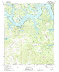
1972 Map of Peel
USGS Topo · Published 1988About this map
The waters of Bull Shoals Lake and the White River dominate this borderland where Marion County, Arkansas, meets Taney County and Ozark County, Missouri. This map reflects a landscape transformed by the reservoir, yet it preserves the locations of numerous family-named hollows and ridges that defined the pre-inundation geography. Genealogists can locate several historic burial sites, including the Keesee Ch Cem near the southern border and the Riddle Cem tucked into a bend of the river.
Find a feature on this map
57 named features on this map. Tap any name to fly to it.
Don’t see what you’re looking for? This feature index may not catch every label — zoom into the map to look around manually.
Map Details
Editions of this 1972 Peel Map
2 editions found
Other maps of this area

1893 · Yellville
USGS Topo · 1:125,000

1903 · Yellville
USGS Topo · 1:125,000

1905 · Yellville
USGS Topo · 1:125,000

1929 · Yellville
USGS Topo · 1:125,000

1936 · Thornfield
USGS Topo · 1:48,000

1943 · Protem
USGS Topo · 1:62,500

1943 · Thornfield
USGS Topo · 1:62,500

1945 · Harrison
USGS Topo · 1:250,000

1945 · Thornfield
USGS Topo · 1:62,500

1949 · Harrison
USGS Topo · 1:250,000