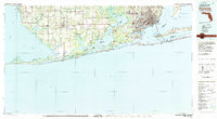
1978 Map of Pensacola
USGS Topo · Published 1986About this map
Pensacola and the surrounding Gulf Coast bays define this 1970s landscape, illustrating the heavy military and maritime footprint across the Alabama Florida border. The map provides a detailed view of the extensive US Naval Reservation and facilities like Pensacola Naval Air Station and US Naval Air Station Saufley Field. Settlement patterns in Baldwin Co and Escambia Co range from the established city streets of West Pensacola and Warrington to smaller coastal communities like Magnolia Springs and Bon Secour. The intricate coastline of Pensacola Bay, Perdido Bay, and Mobile Bay is interconnected by the Intracoastal Waterway, supporting a regional economy tied to the water. Long barrier features including Santa Rosa Island, home to Fort Pickens State Park, and Perdido Key buffer the mainland from the Gulf of Mexico.
Find a feature on this map
103 named features on this map. Tap any name to fly to it.
Don’t see what you’re looking for? This feature index may not catch every label — zoom into the map to look around manually.
Map Details
Editions of this 1978 Pensacola Map
3 editions found
Other maps of this area

1920 · Milton
USGS Topo · 1:62,500

1920 · Robertsdale
USGS Topo · 1:62,500

1921 · Holley
USGS Topo · 1:62,500

1921 · Bon Secour
USGS Topo · 1:62,500

1921 · Pensacola
USGS Topo · 1:62,500

1921 · Point Clear
USGS Topo · 1:62,500

1921 · Fairhope
USGS Topo · 1:62,500

1921 · Dauphin Island
USGS Topo · 1:62,500

1921 · Fort Barrancas
USGS Topo · 1:62,500

1921 · Muscogee
USGS Topo · 1:62,500