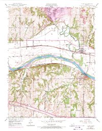
1949 Map of Perry
USGS Topo · Published 1971About this map
The Kansas River flows through this 1949 topographic survey, marking the jurisdictional divide between Jefferson and Douglas counties. This area is a critical junction of mid-century transportation, featuring the Union Pacific and Atchison Topeka and Santa Fe railroads, alongside the developing Kansas Turnpike shown in purple revisions. A significant shift in the landscape is recorded with the presence of the Perry Reservoir and its associated Perry Public Use Area, which altered the northern reaches of the Delaware River.
Find a feature on this map
37 named features on this map. Tap any name to fly to it.
Don’t see what you’re looking for? This feature index may not catch every label — zoom into the map to look around manually.
Map Details
Editions of this 1949 Perry Map
4 editions found

Other maps of this area

1885 · Lawrence
USGS Topo · 1:125,000

1886 · Oskaloosa
USGS Topo · 1:125,000

1888 · Oskaloosa
USGS Topo · 1:125,000

1889 · Burlingame
USGS Topo · 1:125,000

1889 · Topeka
USGS Topo · 1:125,000

1889 · Lawrence
USGS Topo · 1:125,000

1894 · Burlingame
USGS Topo · 1:125,000

1894 · Oskaloosa
USGS Topo · 1:125,000

1894 · Topeka
USGS Topo · 1:125,000

1947 · Lawrence
USGS Topo · 1:250,000