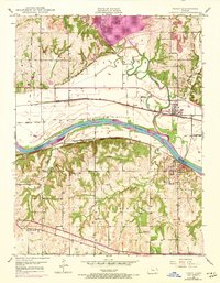
1949 Map of Perry
USGS Topo · Published 1973About this map
The Delaware River flows south into the Kansas River valley, a region defined by complex transport networks and early settlement patterns near the border of Jefferson and Douglas counties. The landscape shows the significant impact of water management through the presence of Perry Lake, with its associated Outlet Public Use Area and Thompsonville Public Use Area. Two major historical rail lines, the Union Pacific and the Atchison Topeka and Santa Fe, parallel the rivers, reflecting the era's reliance on rail for commerce between towns like Perry, Lecompton, and Newman. Traceable historical markers include the Old Indian Bdy and several rural institutions such as Greenwood Valley Sch and Young Sch. Local history is well-preserved through numerous burial grounds including Lecompton Cem and Big Springs Cem, while the Kansas Turnpike cuts across the southern hills near Big Springs.
Find a feature on this map
33 named features on this map. Tap any name to fly to it.
Don’t see what you’re looking for? This feature index may not catch every label — zoom into the map to look around manually.
Map Details
Editions of this 1949 Perry Map
4 editions found

Other maps of this area

1885 · Lawrence
USGS Topo · 1:125,000

1886 · Oskaloosa
USGS Topo · 1:125,000

1888 · Oskaloosa
USGS Topo · 1:125,000

1889 · Burlingame
USGS Topo · 1:125,000

1889 · Topeka
USGS Topo · 1:125,000

1889 · Lawrence
USGS Topo · 1:125,000

1894 · Burlingame
USGS Topo · 1:125,000

1894 · Oskaloosa
USGS Topo · 1:125,000

1894 · Topeka
USGS Topo · 1:125,000

1947 · Lawrence
USGS Topo · 1:250,000