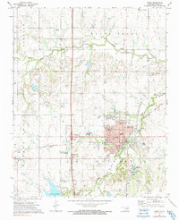
1972 Map of Perry
USGS Topo · Published 1991About this map
Perry serves as a major rail hub in north-central Oklahoma, where the St Louis - San Francisco and Atchison Topeka and Santa Fe lines intersect. This 1970s landscape shows the city's civic core anchored by the Courthouse and Armory, while the Cherokee Strip Museum preserves the area's pioneer heritage. Beyond the corporate boundary, the terrain is defined by the Oakdale Valley and Warren Valley, with drainage provided by Black Bear Creek and Cow Creek. The presence of numerous Oil Wells and Gas Wells throughout the township reflects the region's energy-based economy, while local landmarks like the Lutheran Sch and Mt Carmel Cem provide critical points of reference for genealogists. Water resources like Perry Lake and Wills Lake offer a counterpoint to the industrial Sewage Disposal Ponds and various Gravel Pits dotting the countryside.
Find a feature on this map
50 named features on this map. Tap any name to fly to it.
Don’t see what you’re looking for? This feature index may not catch every label — zoom into the map to look around manually.
Map Details
Editions of this 1972 Perry Map
2 editions found
Other maps of this area

1893 · Mulhall
USGS Topo · 1:62,500

1893 · Stillwater
USGS Topo · 1:62,500

1955 · Enid
USGS Topo · 1:250,000

1958 · Enid
USGS Topo · 1:250,000

1966 · Lake Carl Blackwell
USGS Topo · 1:24,000

1972 · Perry NW
USGS Topo · 1:24,000

1972 · Red Rock
USGS Topo · 1:24,000

1972 · Ceres
USGS Topo · 1:24,000

1972 · Perry
USGS Topo · 1:24,000

1972 · Lucien
USGS Topo · 1:24,000