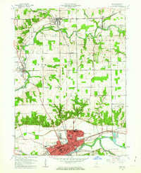
1960 Map of Peru
USGS Topo · Published 1962About this map
The Wabash River and its major tributaries, the Eel River and Mississinewa River, converge in this central Indiana landscape, dictating the development of the city of Peru and surrounding hamlets. The map documents a complex lattice of transportation, where the Pennsylvania Railroad, Erie Railroad, and Chesapeake and Ohio Railroad intersect. A notable historical marker, the Old Indian Treaty Boundary, cuts diagonally across the townships, reflecting early nineteenth-century land partitions. Within the grid of Peru, civic landmarks like Dukes Memorial Hospital, St Charles Church, and the sprawling Mount Hope Cemetery are clearly delineated. Smaller settlements like Mexico, Denver, and Chili serve as rural nodes, often centered around local institutions such as Richland Sch or the Westlawn Cem.
Find a feature on this map
66 named features on this map. Tap any name to fly to it.
Don’t see what you’re looking for? This feature index may not catch every label — zoom into the map to look around manually.
Map Details
Editions of this 1960 Peru Map
4 editions found
Other maps of this area

1951 · Peru
USGS Topo · 1:24,000

1951 · Onward
USGS Topo · 1:24,000

1951 · Twelve Mile
USGS Topo · 1:24,000

1951 · Bunker Hill
USGS Topo · 1:24,000

1951 · Richvalley
USGS Topo · 1:24,000

1953 · Peoria
USGS Topo · 1:24,000

1953 · Danville
USGS Topo · 1:250,000

1953 · Muncie
USGS Topo · 1:250,000

1955 · Danville
USGS Topo · 1:250,000

1956 · Muncie
USGS Topo · 1:250,000