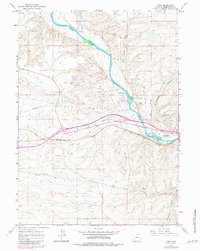
1961 Map of Peru
USGS Topo · Published 1981About this map
The Green River carves a deep path through the high desert of Sweetwater County, creating a corridor for transportation and settlement beneath the prominent Blue Rim. This 1961 field check, updated with 1970s aerial data, shows the concentration of activity along the Union Pacific railroad line where the small stations of Peru and Riview sit near the riverbanks. The map documents the localized growth of James Town and Riovista south of the tracks, contrasted against the older agricultural footprint of the Shaul Ranch and Gaensslen Ranch to the north.
Find a feature on this map
22 named features on this map. Tap any name to fly to it.
Don’t see what you’re looking for? This feature index may not catch every label — zoom into the map to look around manually.
Map Details
Editions of this 1961 Peru Map
3 editions found
Other maps of this area

1954 · Rock Springs
USGS Topo · 1:250,000

1957 · Mc Kinnon Junction
USGS Topo · 1:62,500

1957 · Firehole Basin
USGS Topo · 1:62,500

1958 · Rock Springs
USGS Topo · 1:250,000

1961 · Scott Spring
USGS Topo · 1:24,000

1961 · Peru
USGS Topo · 1:24,000

1961 · Austin Ranch
USGS Topo · 1:24,000

1961 · Stevens Flat
USGS Topo · 1:24,000

1961 · Green River
USGS Topo · 1:24,000

1961 · Bryan
USGS Topo · 1:24,000