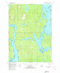
1949 Map of Petersburg A-4
USGS Topo · Published 1974About this map
Prince Of Wales Island is defined here by a dense network of coastal waterways and interior freshwater systems within the Tongass National Forest. The landscape reflects a mid-century reliance on maritime and aerial access, highlighted by the North Whale Seaplane Base and Neck Lake Camp Seaplane Base. These points of entry, along with a Gaging Sta and a small Cabin, suggest an era of remote resource management and limited seasonal habitation.
Find a feature on this map
35 named features on this map. Tap any name to fly to it.
Don’t see what you’re looking for? This feature index may not catch every label — zoom into the map to look around manually.
Map Details
Editions of this 1949 Petersburg A-4 Map
3 editions found
Other maps of this area

1948 · Petersburg B-3
USGS Topo · 1:63,360

1949 · Craig D-3
USGS Topo · 1:63,360

1949 · Petersburg B-5
USGS Topo · 1:63,360

1949 · Petersburg A-3
USGS Topo · 1:63,360

1949 · Craig D-4
USGS Topo · 1:63,360

1949 · Petersburg A-5
USGS Topo · 1:63,360

1949 · Petersburg A-4
USGS Topo · 1:63,360

1949 · Petersburg B-4
USGS Topo · 1:63,360

1950 · Craig D-3
USGS Topo · 1:63,360

1951 · Craig D-5
USGS Topo · 1:63,360