
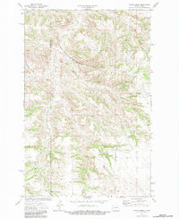
1974 Map of Petes Creek
USGS Topo · Published 1977About this map
Killdeer Mountain State Game Management Area occupies a significant portion of this terrain in western North Dakota, straddling the boundary between McKenzie and Dunn Counties. The landscape is defined by its complex drainage systems and prominent ridgelines, including the Dillinger Divide and Eisenhower Divide. These high points separate numerous watercourses such as Petes Creek, Russian Creek, and White Tail Creek, which carve deep into the plateau. Local industry and land use are evidenced by a Scoria Pit and multiple Gravel Pits, while a lone Grave stands as a quiet marker of early human presence in this sparsely settled region. The presence of Rhoades in the southwestern corner suggests early ranching or family-named landmarks established before modern development.
Find a feature on this map
18 named features on this map. Tap any name to fly to it.
Don’t see what you’re looking for? This feature index may not catch every label — zoom into the map to look around manually.
Map Details
Editions of this 1974 Petes Creek Map
2 editions found
Other maps of this area

1953 · Watford City
USGS Topo · 1:250,000

1957 · Watford City
USGS Topo · 1:250,000

1958 · Lone Butte SE
USGS Topo · 1:24,000

1958 · Lone Butte
USGS Topo · 1:24,000

1958 · North Killdeer Mountain
USGS Topo · 1:24,000

1967 · Watford City
USGS Topo · 1:250,000

1974 · Killdeer
USGS Topo · 1:100,000

1974 · Grassy Butte SW
USGS Topo · 1:24,000

1974 · Fayette
USGS Topo · 1:24,000
1974 · Grassy Butte
USGS Topo · 1:24,000