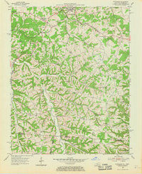
1954 Map of Petroleum
USGS Topo · Published 1969About this map
Scottsville serves as the focal point of this mid-century landscape where the Louisville and Nashville railroad winds through the hills of Allen County. The map captures a moment when rural life centered on a dense network of country churches and small schools, such as Hickory Hill Ch, Dover Ch, and Mt Union Sch. Evidence of the region's extractive economy is visible through numerous Oil Wells scattered across the northern sections, particularly near Watkins Branch and Rough Creek.
Find a feature on this map
63 named features on this map. Tap any name to fly to it.
Don’t see what you’re looking for? This feature index may not catch every label — zoom into the map to look around manually.
Map Details
Editions of this 1954 Petroleum Map
4 editions found
Other maps of this area

1921 · Bowling Green
USGS Topo · 1:62,500

1923 · Bowling Green
USGS Topo · 1:62,500

1926 · Scottsville
USGS Topo · 1:62,500

1928 · Adolphus
USGS Topo · 1:48,000

1931 · Lafayette
USGS Topo · 1:62,500

1931 · Adolphus
USGS Topo · 1:62,500

1942 · Gallatin
USGS Topo · 1:100,000

1954 · Austin
USGS Topo · 1:24,000

1954 · Petroleum
USGS Topo · 1:24,000

1954 · Scottsville
USGS Topo · 1:24,000