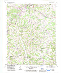
1954 Map of Petroleum
USGS Topo · Published 1995About this map
Scottsville sits at the northern edge of this map, serving as a hub for the rolling terrain along the Kentucky-Tennessee border during the mid-20th century. Numerous Oil Wells dot the landscape near Rodemer Branch and Watkins Branch, indicating the localized petroleum extraction that gave the community of Petroleum its name. The map documents a dense network of rural infrastructure, from the Waterworks and hospital in the north to isolated country schools like Union Chapel Sch and Shady Grove Sch.
Find a feature on this map
56 named features on this map. Tap any name to fly to it.
Don’t see what you’re looking for? This feature index may not catch every label — zoom into the map to look around manually.
Map Details
Editions of this 1954 Petroleum Map
4 editions found
Other maps of this area

1921 · Bowling Green
USGS Topo · 1:62,500

1923 · Bowling Green
USGS Topo · 1:62,500

1926 · Scottsville
USGS Topo · 1:62,500

1928 · Adolphus
USGS Topo · 1:48,000

1931 · Lafayette
USGS Topo · 1:62,500

1931 · Adolphus
USGS Topo · 1:62,500

1942 · Gallatin
USGS Topo · 1:100,000

1954 · Austin
USGS Topo · 1:24,000

1954 · Petroleum
USGS Topo · 1:24,000

1954 · Scottsville
USGS Topo · 1:24,000