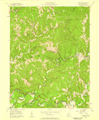
1957 Map of Petroleum
USGS Topo · Published 1958About this map
The extractive industries that fueled West Virginia’s growth are etched across this landscape, marked by clusters of Oil Wells and Gas Wells throughout the Walker and Grant districts. The Baltimore and Ohio railroad corridor serves as the primary artery of the region, passing through the Eaton Tunnel and connecting the namesake settlement of Petroleum with Eaton. This rail line follows the winding valley of Goose Creek, providing a vital link for the energy and timber resources harvested from the surrounding hills.
Find a feature on this map
62 named features on this map. Tap any name to fly to it.
Don’t see what you’re looking for? This feature index may not catch every label — zoom into the map to look around manually.
Map Details
Editions of this 1957 Petroleum Map
4 editions found
Other maps of this area

1904 · Marietta
USGS Topo · 1:62,500

1906 · Saint Marys
USGS Topo · 1:62,500

1906 · Elizabeth
USGS Topo · 1:62,500

1907 · Harrisville
USGS Topo · 1:62,500

1924 · St Marys
USGS Topo · 1:62,500

1924 · Harrisville
USGS Topo · 1:62,500

1924 · Marietta
USGS Topo · 1:62,500

1924 · Elizabeth
USGS Topo · 1:62,500

1926 · Elizabeth
USGS Topo · 1:62,500

1926 · Harrisville
USGS Topo · 1:62,500