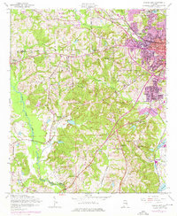
1955 Map of Phenix City
USGS Topo · Published 1976About this map
Phenix City serves as the focal point of this mid-century landscape, positioned where the industrial rail lines of the Central of Georgia meet the residential expansion of Girard and Golden Acres. The map reveals a distinct urban-rural divide as the dense grid of the city gives way to the winding course of Cochgalechee Creek and the scattered settlements of Ladonia and Brickyard. This era shows a significant concentration of communication infrastructure, including the TV Tower (WRBL) and TV Tower (WDAK), reflecting the region's mid-century growth. To the south and west, the landscape is defined by traditional community anchors such as Friendship Ch and Uchee Hill Ch, while industrial sites like Kaolin and the Brickyard Sch highlight the local economic drivers of the period. The presence of numerous family and church burial grounds, such as Evans Cem and Bethlehem Cem, provides significant genealogical value for the area.
Find a feature on this map
53 named features on this map. Tap any name to fly to it.
Don’t see what you’re looking for? This feature index may not catch every label — zoom into the map to look around manually.
Map Details
Editions of this 1955 Phenix City Map
5 editions found

Other maps of this area

1907 · Talbotton
USGS Topo · 1:125,000

1907 · Opelika
USGS Topo · 1:125,000

1908 · Columbus
USGS Topo · 1:62,500

1909 · Opelika
USGS Topo · 1:125,000

1914 · Seale
USGS Topo · 1:62,500

1929 · Columbus
USGS Topo · 1:48,000

1947 · Columbus
USGS Topo · 1:62,500

1949 · Fort Mitchell
USGS Topo · 1:24,000

1949 · Columbus
USGS Topo · 1:24,000

1950 · Fort Benning
USGS Topo · 1:24,000