
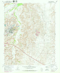
1970 Map of Phillips
USGS Topo · Published 1973About this map
The heavy industrial landscape of the Texas Panhandle is defined here by the extensive Borger Oil Field and the neighboring Moore Watkins Oil Field. Established as a company town in the late 1920s, Phillips sits at the heart of this activity, showing a dense grid of residential streets, a High Sch, and an Athletic Field surrounded by a complex network of pipelines and storage tanks. The terrain is deeply dissected by the drainages of Dixon Creek and Bear Creek, which flow toward the wide valley of the Canadian River in the northwest. Scattered throughout this petroleum-rich area are signs of rural community life, including the Haile Ch and Spring Creek Sch, alongside extractive infrastructure like Gravel Pits, Pitch Pits, and a Caustic Pit.
Find a feature on this map
25 named features on this map. Tap any name to fly to it.
Don’t see what you’re looking for? This feature index may not catch every label — zoom into the map to look around manually.
Map Details
Editions of this 1970 Phillips Map
2 editions found
Other maps of this area

1953 · Plemons
USGS Topo · 1:24,000

1953 · Stinnett
USGS Topo · 1:24,000

1953 · Borger SE
USGS Topo · 1:24,000

1953 · McBride
USGS Topo · 1:24,000

1953 · Phillips
USGS Topo · 1:24,000

1953 · Borger
USGS Topo · 1:24,000

1954 · Amarillo
USGS Topo · 1:250,000

1958 · Amarillo
USGS Topo · 1:250,000

1963 · Skellytown
USGS Topo · 1:24,000

1970 · Borger
USGS Topo · 1:24,000